

Overview
The Titan 2 GPS tracking system strives to offer more than just stats on an athletes total running distance. The insight derived from the sensor provides sports coaches with a comprehensive monitoring tool that aims to reduce athlete injury occurrences and optimise performance. In particular the management of running profiles and load parameters provide users with a numerical means of measuring an athletes physical output.

However with all this being said, GPS sensors in team sports are not a new phenomenon and have been around for some time now. Rather than directly targeting the top tier professional markets of the NBA, NFL and EPL, the Titan 2 aims to service the growing demand by college, semi-professional and elite youth sporting teams for an affordable GPS system. Moreover, Titan aim to offer their customers a great user experience through premium hardware and a wide range of features.
Although the system provides simple to understand metrics like running distance and top speed, we believe it is best suited for sport scientist, strength and conditioning coaches and team sports coaches. That is due to the specialised knowledge that is required to turn the data derived from the GPS units into actionable insights that can improve team performance.
Tech Involved
At the heart of any GPS tracking system is the sensors capability to effectively connect to satellites orbiting in space. Surprisingly at the price point they are selling at Titan are very confident with the quality of their hardware. They claim to be utilising industry first technology with a Triple GNSS sensor. This means that the sensor doesn’t only connect to the United States’ GPS satellites but also the Russian operated Glonass satellites and European Union operated Galileo set of satellites. The benefits for the user is more accurate data and greater product reliability through reducing the possibility of signal loss. This is supplemented by the product collecting over 150 different metrics, in the process providing a comprehensive performance analysis tool.

Although the device features industry first technology their units are still affected by GPS technology’s core limitation of not working properly indoors. This is due to signal interference by physical barriers, namely walls and roofs. Despite this limitation Titan still make it possible to collect over 35 metrics indoors including step rate and gforce loads through the combination of an accelerometer, gyroscope and a magnetometer.
Unboxing
The competitively priced system comes with all the essentials including a GPS sensor, a compression bib to place the device in and a micro USB cord for charging and data syncing. Pre tax and shipping the sensor itself costs $200USD with $ 20 a year for a subscription for the online cloud platform which is the basis for analysis and video synchronisation.

The GPS units small size and light weight is familiar to other offerings on the market. The device feels robust and by no means feels like it will break easy. The initial device we received looked rustic as if the case was a 3d printed prototype. After our feedback the team at Titan then sent us a new device which is featured in the image below. The finishing on the case is much better and definitely feels production grade. Although the sensor is designed for outdoor use there is no mention we have seen of it being labelled as waterproof/resistant. This brings some concern over the electronic components durability in wet conditions.

Titan have taken a conservative approach with the bib to place the sensor in during use. Like many other manufacturers they have opted for a compression crop top with a pouch at the back that holds the sensor in place during activities. This is essential for the athlete during use not to disturb them and reduce the collection of noisy data from the sensor unintentionally rattling around.
Setup
The process to view your GPS data is pretty straight forward. In a nutshell it involves three steps. The first is the collection of the GPS data. The second is using the desktop software to upload and sync the data to the cloud. The last is analysing the data on the web-browser based application.
Equipment List
To get started you will need the following equipment:
- A mac or windows computer (video editor unavailable on mac)
- GPS Sensor
- GPS Bib
- Micro USB Cable
Desktop Software
Prior to using the sensor the Titan Sync desktop software needs to be downloaded. There is a version for Mac Os and Windows operating systems. Having tried both they are an almost identical user experience. To upload video footage you will need to download the windows exclusive Titan Video software. This is a seperate software to the Titan Sync and enables the video to be uploaded to the cloud.
Collecting Data
To start collecting data you press the sensor button once and then hold until the blue light goes solid. It is recommended to turn the sensor on 10-15 mins before the event to ensure connection with satellites have been made and should be done outdoors. Once on it is a matter of placing it in the compression bib and wearing it. Though the bib was tight fitting it was by no means restrictive during use. From here you are free to commence your activity with all metrics being collected automatically. The product claims 7 hours of battery life and didn’t cause any problems during my 90 minutes soccer match. The main let down was that there is no identification of battery percentage on the device making it impossible to know how much battery you have left
Syncing GPS Data
Once your session is completed to view your data the device needs to be connected to your computer via a micro usb cable using the Titan Sync software. This can take several minutes to upload to the cloud. To view your session results their is a further 10-15 minute wait. Despite taking this long in most cases getting results are not instantly necessary. As all our analysis was done post we can’t comment on live feedback options.
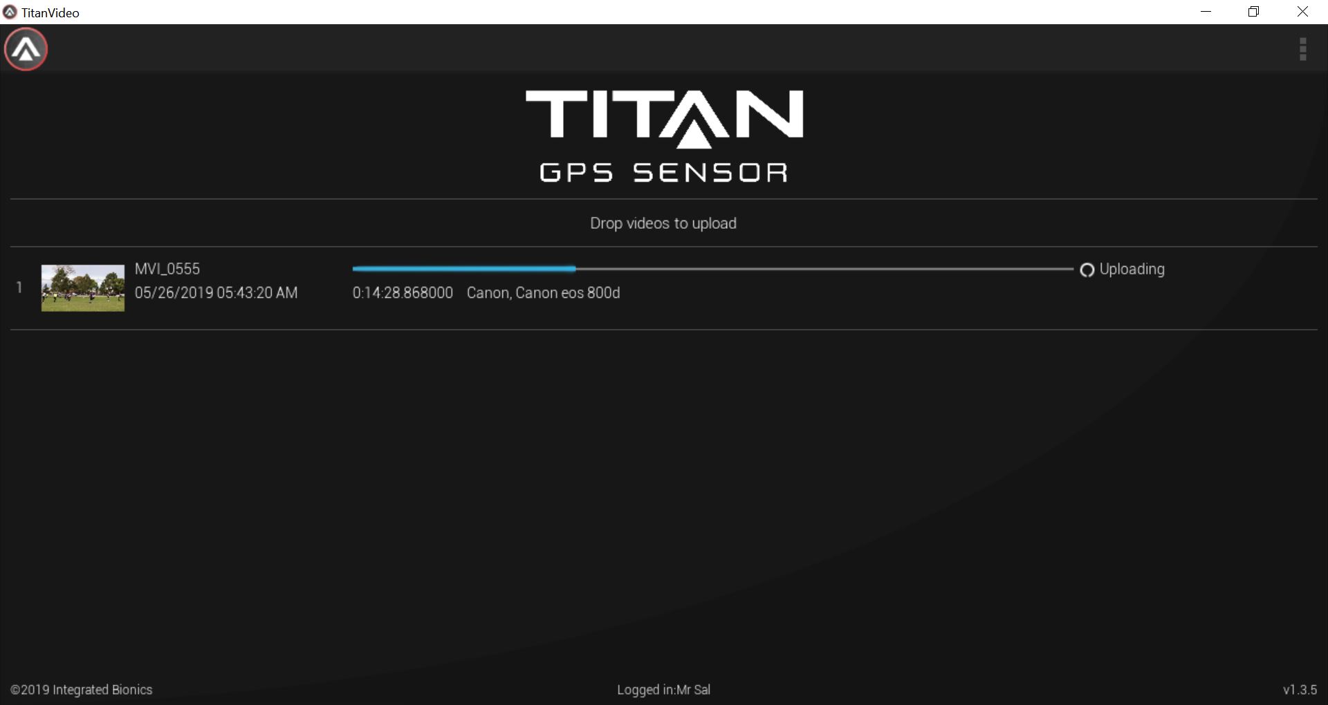
Uploading Videos
To upload videos there is a seperate windows exclusive software called Titan Video. Here you can upload videos upto 5GB in size. The files are stored in the cloud which can be used to view on the online platform. We were not fond of having a seperate software and would’ve much preferred it as a combined feature with the Titan sync software.
Viewing Data
Once the data is synced to the cloud viewing your session results are extremely versatile. As it is a web app this can be accessed on a computer, tablet or mobile.
Analysis Of Product Features
For an entry priced GPS device, the Titan 2 doesn’t hold back when it comes to offering a wide range of features.
Team Stats (Home) Screen
The first screen the user will deal with is the team stats page which is equivalent to the home screen. Displayed here is an overview on all main stats ranging from total running distance to more in depth metrics like sprint profiles in where sprint efforts are broken into speed thresholds. The user also has the option to select a particular session, a particular player and which specific stats to display. Our experience with this page was pleasant. The dashboards and data visualisation are aesthetically pleasing, quick to load and intuitive to use. We also found it to work well on mobile browser.
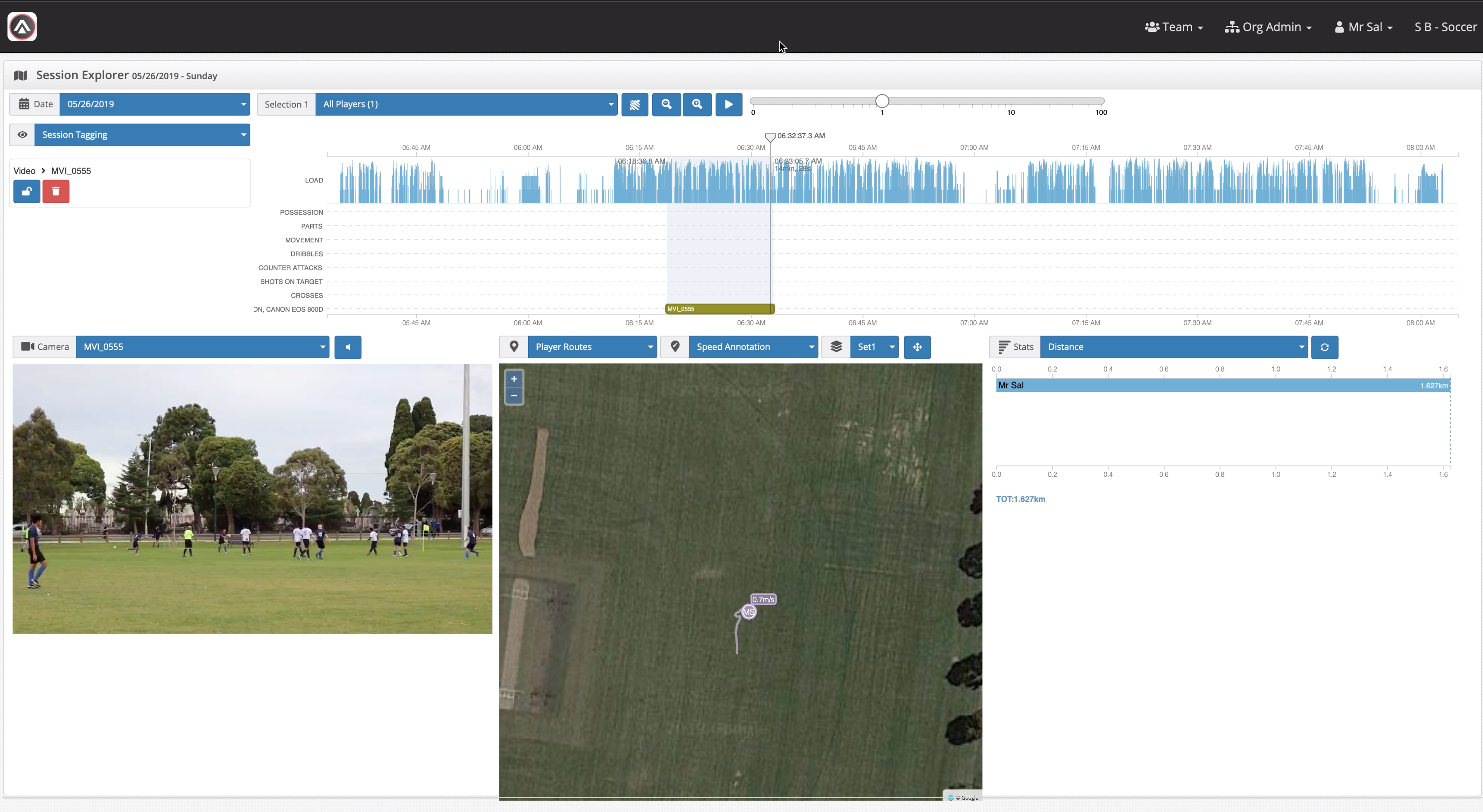
Session Explorer(Main Mode)
The session explorer page is the main mode and is great for a more in depth GPS tracking analysis. Like the home screen coaches and practitioners have a wide arsenal of metrics to choose from. When on this page the first thing that catches the eye is the embedded Google Maps satellite view which highlights the location of your session. This acts as the base of many of the tracking features including a heatmap which is the summary of your running efforts, similar to what you may have seen on television. Unlike most the graphics in the app we found this to look rather messy and had mixed accuracy. Especially when zooming into the field of play.

Our favourite feature in this mode is the annotated player routes which are overlaid on the google maps satellite view. The player movement tail and showcasing of current running speed made it out to be a powerful analysis tool. Titan also allows a degree of customisation with this feature with users able to control playback speed and select countless other metrics to overlay on the map. On all of the 5 league soccer matches that we tested this product, none of the court lines were visible in the google maps satellite images. We believe this feature could be made better by enabling the option to overlay sporting fields on the google maps satellite images acting like a radar map in the FIFA video games. Thus making out a better tactical analysis tool.
Synchronising GPS Data With Video
Although the synchronisation of video footage and GPS athlete tracking data is described by Titan as the ultimate coaching tool, we believe that Titan have bitten off more than they chew with this feature.
Prior to synchronising GPS data the video file needs to be uploaded to the cloud using the windows exclusive Titan Video desktop software. For our sample we only used a 14 minute 720p video footage of one of my matches. We found it took a considerably long time to transcode then upload the file this is despite our internet having reasonably decent upload speeds.
Once uploaded the Titan Video software is no longer needed with all other process being done on the web app and thus available to Mac users. Prior to analysing and syncing the video with GPS data there are some preparations to make your experience better. The video manager page allows users to manage their videos and the sports code tab enables users to create their own code windows. This acts as a way to segregate the video footage into key events in the game and is a common feature of many sports video analysis software.
The synchronisation of the video and GPS data happens in the session explorer(Main Mode). Here the date and time of the video recording are automatically aligned with the GPS data. Note due to minor differences in the camera time to that of the GPS, repositions may need to be done. Unfortunately though we found this feature to be extremely frustrating due to the lag. This is regardless of our relatively fast internet speeds. In our opinion it is a feature which has a lot of potential but currently as of this review is not up to production standard. If they provided a desktop alternative it could potentially overcome the problems we faced.
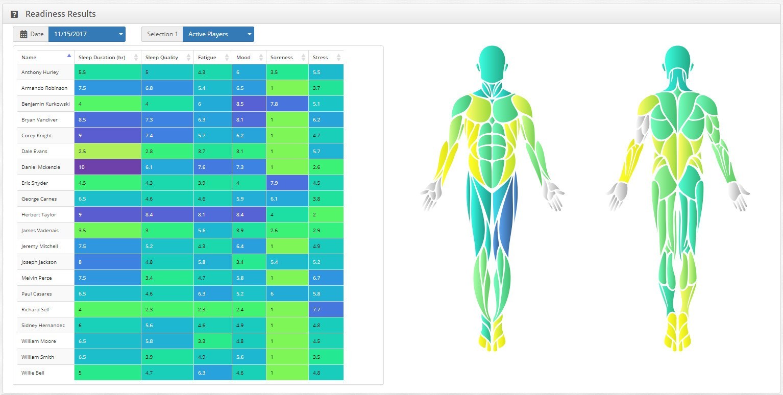
RPE & Muscle Soreness
Titan haven’t left a stone untouched in creating an athlete monitoring ecosystem. Amongst their features is RPE survey where coaches and athletes can put down the subjective measure of how hard they have worked in the session. Additionally there is also the logging of muscle soreness in where users can select specific location and severity. This links in well with their recently launched mobile app.
Exporting Data
For practitioners who are looking to combine Titans GPS data with their own external databases there is the option to export reports. The user gets to select the focus of the report, the metrics as well as whether they want it in a pdf or xls file for use with excel. The company has gone to great detail with this feature including the option to select font size for the report. Though simple it is an extremely valuable tool.
Conclusion
Though the Titan 2 GPS sensor may not be a disruptive technology from an innovation perspective, it provides amazing value for money with a wide range of features. For the price point they are selling at it was interesting to see them use an industry first Triple GNSS connection that enabled more accurate data and better product reliability. The online web application for viewing stats was in most instances simple to use, had clean visuals and displayed countless metrics. We also liked the versatility of the platform that allowed the gps data to be viewed on a computer, tablet or mobile phone. Our main criticisms were that the uploading process of video and GPS data wasn’t a great user experience as two seperate desktop softwares were required. We also found the video synchronisation tool on the web app to be frustrating to use due to considerable lag. Overall if you are after a reliable GPS system with a wide range of features this is definitely worth the $200 USD for the sensor and $20 annual subscription. Due to the usefulness of the system it is a product we will continuously use throughout our soccer season and most likely for many more to come.
Thanks to our friends at Kitradar who provided us with the sensor for testing and review. If you are interested in getting one, do check it out on Kitradar’s website: Titan 2 Sensor.
That’s the end of this blog, comment below and tell us about your experiences with the Titan 2 GPS Sensor.
